In 1996, a blizzard in Everest’s notorious ‘death zone’ killed ‘Green Boots’. Now, a fresh expedition plans to retrieve his body, and establish his identity Thirty years after he perished in a small limestone cave near the top of Mount Everest, the body of the climber known only as “Green Boots” may finally be heading home. If successful, the mission into Everest’s notorious “death zone” will als…
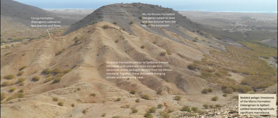
The island of Maio, Cabo Verde, 600 km the west of Senegal, is the only place where Cretaceous mid-ocean floor of the distal Mauritania - Senegal - Guinea Bissau - Conakry (MSGBC) Basin is exposed, providing a unique opportunity to study the early stages of mid Atlantic opening at outcrop. The Basement Complex of Maio comprises...
When a meteoroid strikes, it generates a wave of energy that moves faster than the speed of sound. When all that energy propagates through material in seconds or less before being quickly cooled and resolidified by a secondary wave, it produces glass. Planetary Science Institute Senior Scientist Shawn Wright was looking for such glassy material […]
astronomyearth-sciencegeologyplanetary-science
Frontiers in Earth Science | New and Recent Articles
The Jiao-Liao-Ji belt is one of three major Paleoproterozoic orogenic belts within the North China Craton, yet its tectonic evolution remains controversial. To address this, we investigated the crustal structure using receiver function analysis of 38 broadband seismic stations from profile NCISP-10, which traverses the Liaodong region in the northeastern North China Craton. Our results reveal tha…
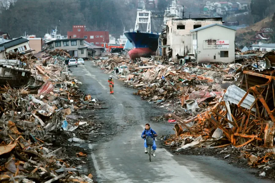
An extremely unusual tectonic movement took place 15 minutes after the Tohoku earthquake in 2011, causing almost the whole of Japan to move 5 millimetres to the east
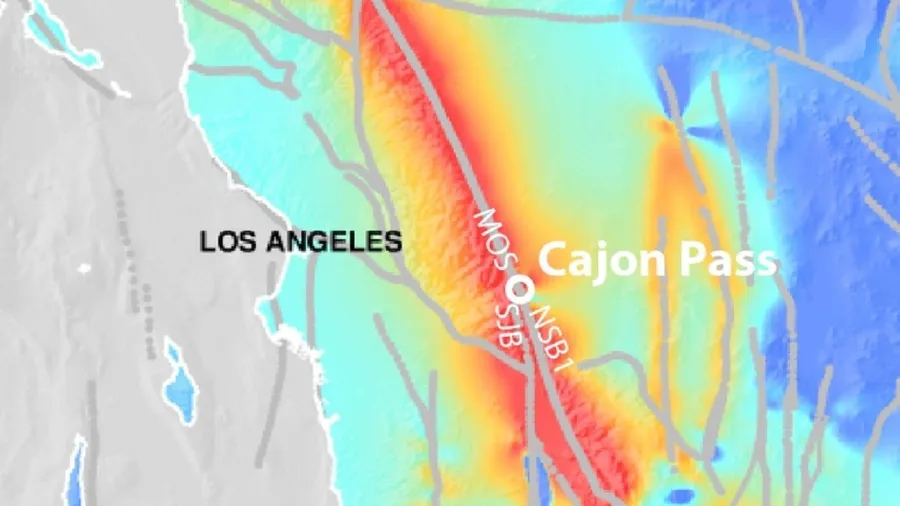
A new study suggests Southern California's major fault system is more stressed than at any point in the last 1,000 years. Researchers found that the Cajon Pass, where the San Andreas and San Jacinto faults meet, could act as an “earthquake gate” that determines whether a future rupture spreads across both faults. Current conditions resemble those that preceded some of the region’s largest histori…
Scientific Reports, Published online: 18 June 2026; doi:10.1038/s41598-026-54132-9 Surrounding rock stability and engineering practice of the 52607 working face approaching a fault-protected coal pillar
Nature Geoscience, Published online: 17 June 2026; doi:10.1038/s41561-026-02018-w Heat flux across the core–mantle boundary is laterally variable, and heat may flow into the core beneath hot piles of dense material such as large low-shear-wave-velocity provinces, according to mantle thermochemical convection models.
Map of the Aleutian Arc in Alaska and the Andreanof study area. The lower map shows where ocean-bottom seismometers and land seismic stations recorded sound waves from an active-source seismic experiment conducted aboard the R/V Marcus G. Langseth , allowing the authors to image the deep structure of the arc crust beneath several Aleutian volcanoes. The black lines show the Langseth ship track an…
earth-sciencegeologyseismology
Frontiers in Earth Science | New and Recent Articles
Accurate landslide susceptibility mapping (LSM) remains challenging because of uncertainty in both model selection and non-landslide sample definition. To address these issues, this paper developed an LSM framework based on the Inter.iamb-Tabu algorithm while explicitly considering non-landslide sampling, using Gangu County, China, as the research area. 124 landslides were established through rem…
Minnie the Minx and Macbeth feature in National Library’s exploration of how rainfall has shaped Scottish science, literature, history and identity It seems fitting that, 250 years ago, one of Scotland’s foremost scientists took a close interest in what is arguably the country’s most famous feature: rain James Hutton, celebrated by Scots as the father of modern geology, went so far as to write a …
LiDAR Patch Activity Use “laser-like” tools to map a hidden landscape just like a NASA scientist. What is LiDAR? Scientists use LiDAR to create topographical maps, meaning a type of map that shows the elevation of different areas. They use this to map different parts of the Earth’s surface, like forests or cities. Some types […] The post Girl Scout Patch – LiDAR appeared first on NASA Science .
San Andreas and San Jacinto fault systems in ‘critically loaded state’, increasing chance of ‘big one’ quake in future Southern California’s San Andreas and San Jacinto fault systems are at their highest levels of tectonic stress in 1,000 years in what scientists describe as a “critically loaded state”, according to a study published earlier this month. “Our results show that stress levels on mul…
earth-sciencegeology
research.io
Sign up to keep scrolling
Create your feed subscriptions, save articles, keep scrolling.